Ahmedabad : The cyclonic storm ‘Vayu’, threatened by the coastal areas of Gujarat, suddenly changed its way late Wednesday night, but the crisis is not yet fully avoided. Indian Meteorological Department (IMD) said on Thursday morning that due to some sudden changes in the movement, the chances of cyclone collision with Gujarat’s coast have reduced considerably. But there may be damage due to strong winds and heavy rains.
The Gujarat government has ordered the administration to remain on high alert till Friday. The state government has shifted nearly 3 lakh people from other coastal areas to other places till Wednesday night. Along with the closure of all the Airports, the trains were adjourned.
Earlier, the Meteorological Department had expressed the possibility that the extremely dangerous cyclonic storm could reach the coastal areas of Gujarat by Thursday afternoon. But in the report released on Thursday evening, it was said that there is a possibility of turning towards north-east direction after moving slightly further north-west direction of storm located at 110 km southwest of Veraval.
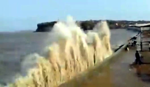
According to the report, the center of the storm will stay away from the shores of Gujarat, but due to its spread of about 900 km, during the next 12 hours, the Saurashtra region poses a threat to 90 to 110 km of high speed winds, dust storms and rain. This will affect the areas of Gir Somnath, Diu, Junagadh, Porbandar and Godbaha Dwarka.
The Meteorological Department has warned about the high tide up to 3.83 meters height on the seashore in Mumbai due to cyclonic storm. Due to this, the common public has been asked to stay away from the coast.
‘Vayu’ didn’t hit Gujarat, still state on high alert


